Digital Public Infrastructure in Hydrological and Meteorological Planning in India
Digital Public Infrastructure in Hydrological and Meteorological Planning plays a crucial role in addressing India's growing climate challenges by integrating fragmented data systems related to water, weather and disaster management. As India faces increasing climate variability, the need for unified digital platforms that connect hydrological and meteorological datasets has become essential for effective climate governance and disaster preparedness.
Introduction
• Digital Public Infrastructure (DPI) refers to interoperable digital systems built on open standards, shared data architecture and public digital platforms that enable efficient delivery of governance and services at scale. In the context of climate governance, DPI enables real-time integration of hydrological, meteorological and socio-economic data for informed decision-making.
• India’s climate vulnerability is deeply connected with water systems. Nearly 75–80% of annual rainfall occurs during the monsoon, and most climate disasters in the country are water-related events such as floods, droughts and cyclones. According to global climate assessments, over 90% of climate hazards manifest through water, making integrated data-driven governance crucial. In this context, the emerging global adaptation frameworks emphasise digital integration of water, sanitation and climate indicators, highlighting the importance of DPI in overcoming “digital fragmentation” in hydrological and meteorological planning.
1. DPI as a tool for integrated hydrological and meteorological data governance
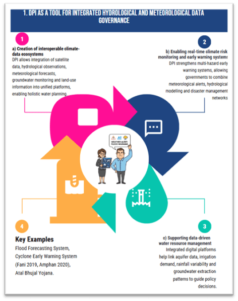
a) Creation of interoperable climate-data ecosystems
- DPI allows integration of satellite data, hydrological observations, meteorological forecasts, groundwater monitoring and land-use information into unified platforms, enabling holistic water planning.
- Platforms like India Meteorological Department digital forecasting systems and Central Water Commission flood forecasting portals demonstrate how digital platforms enable real-time weather and river flow monitoring across multiple states.
- Example – Flood Forecasting System: India operates hundreds of flood forecasting stations, where river basin data is digitally processed and disseminated to state authorities for early preparedness.
b) Enabling real-time climate risk monitoring and early warning systems
- DPI strengthens multi-hazard early warning systems, allowing governments to combine meteorological alerts, hydrological modelling and disaster management networks.
- Digital platforms facilitate dissemination through SMS alerts, mobile applications, and integrated command centres, reducing disaster losses.
- Case Study – Cyclone Early Warning System: Improved digital forecasting and dissemination enabled effective evacuation during Cyclone Fani (2019) and Cyclone Amphan (2020), significantly reducing casualties compared to past cyclones.
c) Supporting data-driven water resource management
- Integrated digital platforms help link aquifer data, irrigation demand, rainfall variability and groundwater extraction patterns to guide policy decisions.
- The National Aquifer Mapping and Management Programme (NAQUIM) has generated large hydrogeological datasets which, when digitised and integrated with planning platforms, enable aquifer-level water governance.
- Example – Atal Bhujal Yojana: Digital monitoring of groundwater extraction and community participation has improved groundwater sustainability in several water-stressed districts.
2. Role of DPI in addressing digital fragmentation in climate governance
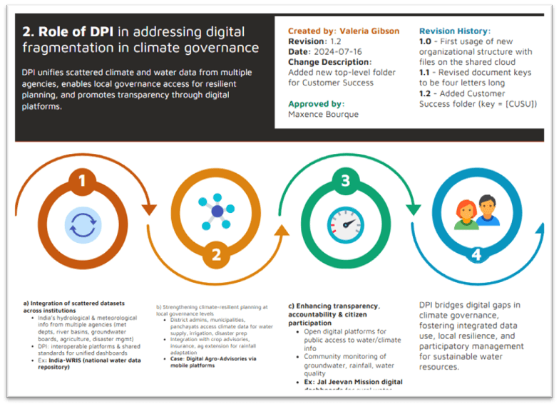
a) Integration of scattered datasets across institutions
- India’s hydrological and meteorological information is generated by multiple agencies such as meteorological departments, river basin authorities, groundwater boards, agricultural institutions and disaster management agencies.
- DPI creates interoperable platforms and shared data standards, allowing these fragmented datasets to converge into unified dashboards.
- Example – India Water Resources Information System (India-WRIS): Developed as a national water data repository integrating data from various agencies, improving planning for irrigation, floods and basin management.
b) Strengthening climate-resilient planning at local governance levels
- DPI allows district administrations, municipalities and panchayats to access climate data and incorporate it into local water supply planning, irrigation management and disaster preparedness.
- Integration of hydrological information with crop advisories, insurance platforms and agricultural extension systems helps farmers adapt to rainfall variability.
- Case Study – Digital Agro-Advisories: Farmers receiving weather-based advisory services through mobile platforms have improved cropping decisions and reduced climate risks in several states.
c) Enhancing transparency, accountability and citizen participation
- Open digital platforms improve public access to water and climate information, promoting accountability in water governance.
- DPI enables community-based monitoring of groundwater, rainfall and water quality, strengthening participatory water management.
- Example – Jal Jeevan Mission digital dashboards: Real-time monitoring of rural drinking water supply infrastructure improves transparency and allows citizens to track service delivery.
3. Limitations and challenges in leveraging DPI for hydrological planning
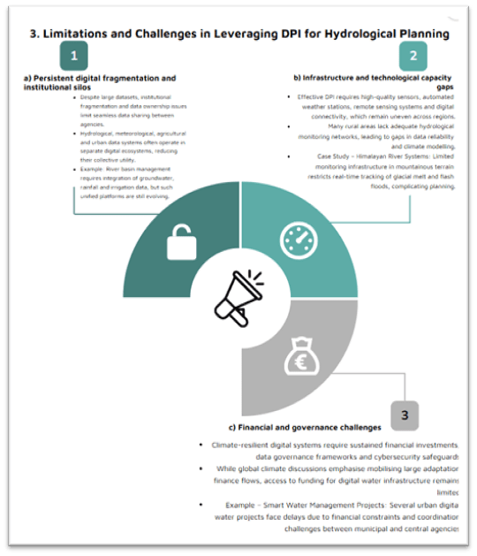
a) Persistent digital fragmentation and institutional silos
- Despite large datasets, institutional fragmentation and data ownership issues limit seamless data sharing between agencies.
- Hydrological, meteorological, agricultural and urban data systems often operate in separate digital ecosystems, reducing their collective utility.
- Example: River basin management requires integration of groundwater, rainfall and irrigation data, but such unified platforms are still evolving.
b) Infrastructure and technological capacity gaps
- Effective DPI requires high-quality sensors, automated weather stations, remote sensing systems and digital connectivity, which remain uneven across regions.
- Many rural areas lack adequate hydrological monitoring networks, leading to gaps in data reliability and climate modelling.
- Case Study – Himalayan River Systems: Limited monitoring infrastructure in mountainous terrain restricts real-time tracking of glacial melt and flash floods, complicating planning.
c) Financial and governance challenges
- Climate-resilient digital systems require sustained financial investments, data governance frameworks and cybersecurity safeguards.
- While global climate discussions emphasise mobilising large adaptation finance flows, access to funding for digital water infrastructure remains limited.
- Example – Smart Water Management Projects: Several urban digital water projects face delays due to financial constraints and coordination challenges between municipal and central agencies.
Conclusion
• Digital Public Infrastructure represents a transformative opportunity to overcome digital fragmentation in hydrological and meteorological planning by enabling real-time data integration, climate-risk forecasting and evidence-based water governance. As climate variability intensifies—with floods, droughts and erratic monsoons affecting millions—integrated digital systems will become the backbone of climate resilience.
• India’s expanding digital public infrastructure ecosystem, growing hydrological datasets and advances in satellite monitoring provide a strong foundation for such integration. Strengthening interoperable data platforms, expanding sensor networks, integrating climate indicators into governance dashboards and mobilising climate finance for digital water systems can significantly enhance adaptive capacity.
• If effectively implemented, DPI can transform water governance from fragmented planning to coordinated, data-driven climate resilience, ensuring that water systems continue to function even under increasing climate stress.
Recap: