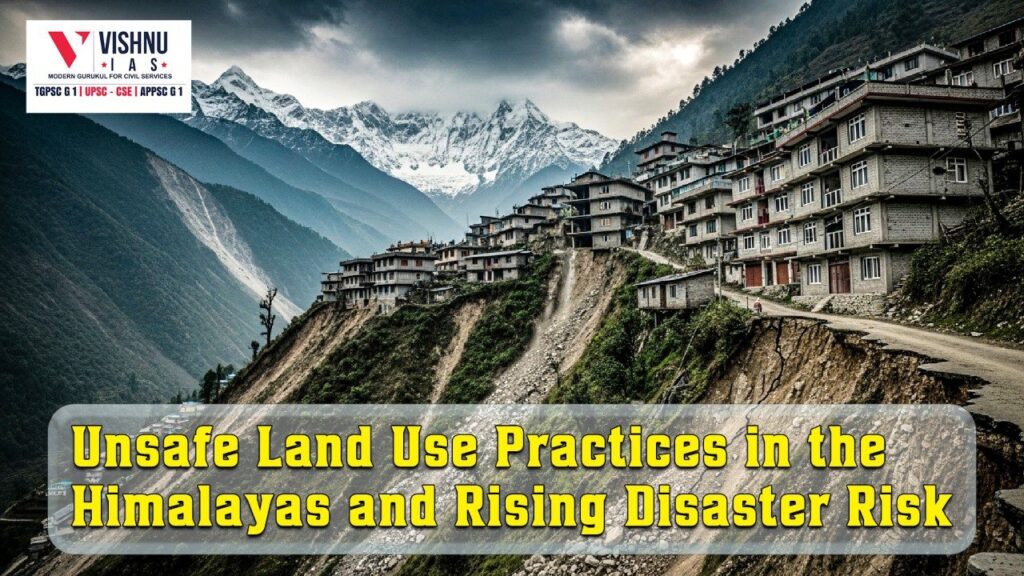
Unsafe Land Use Practices in the Himalayas and Rising Disaster Risk
Unsafe land use practices in the Himalayas have emerged as a major driver of disaster risk, intensifying landslides, flash floods, land subsidence, and ecological degradation. Activities such as indiscriminate slope cutting, poorly assessed tunnelling, and unscientific muck dumping are transforming naturally fragile mountain systems into zones of recurring humanitarian crises, especially under accelerating climate change.
Introduction
- The Himalayan region represents one of the most geologically young, tectonically active, and climate-sensitive mountain systems in the world. Formed by the ongoing collision of the Indian and Eurasian plates, the Himalayas are characterised by fragile lithology, steep slopes, active fault lines such as the Main Central Thrust (MCT), and high dependence on snow and glacier-fed hydrology.
- Recent years have underscored this vulnerability: India experienced near-continuous climate stress through most of 2025, with thousands of fatalities linked to climate-induced disasters, particularly concentrated in Himachal Pradesh and Uttarakhand. Studies tracking high-altitude warming show that Himalayan regions have been warming around 50% faster than the global average since the mid-20th century, intensifying extreme rainfall, glacial retreat, and slope instability.
- Against this backdrop, unsafe land-use practices—notably indiscriminate slope cutting, large-scale tunnelling, and unscientific muck dumping—have emerged as critical human-induced amplifiers of disaster risk, converting natural hazards into recurrent catastrophes.
1. Unsafe Slope Modification and Hill Cutting
Violation of Geological Stability and Angle of Repose
- Extensive road-widening and infrastructure projects often involve vertical or near-vertical hill cutting, ignoring the natural angle at which Himalayan rock and soil remain stable.
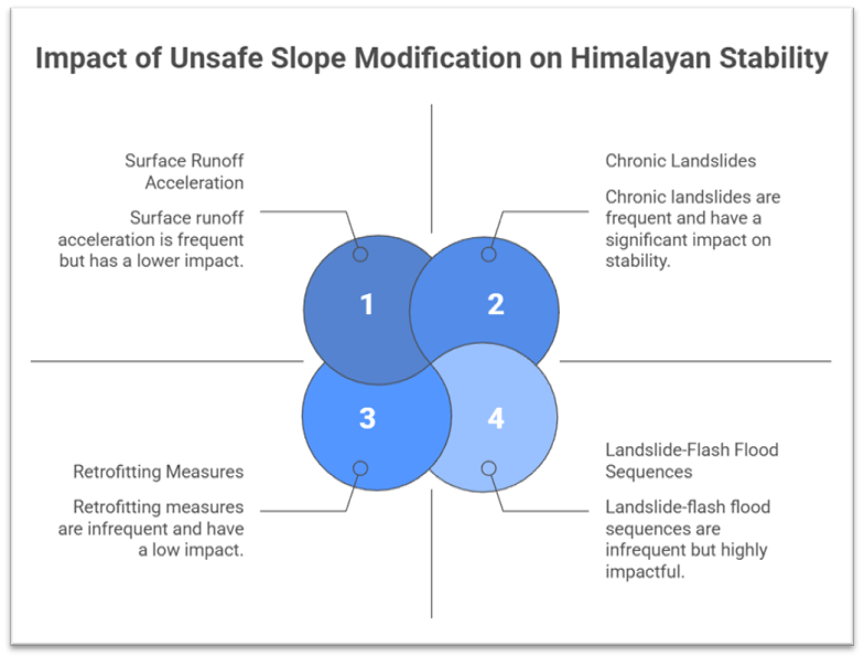
- Such interventions weaken rock mass cohesion in already fractured zones north of the Main Central Thrust, triggering chronic landslides even under moderate rainfall.
- Example: The widening of high-altitude pilgrimage corridors has resulted in the emergence of hundreds of persistent landslide zones, leading to prolonged road closures and repeated loss of connectivity during monsoons.
Deforestation and Loss of Natural Anchors
- Slope cutting is frequently accompanied by the removal of native forest cover, including slow-growing conifers such as Devdar (Deodar), whose deep root systems bind soil and dissipate slope stress.
- The absence of these natural anchors accelerates surface runoff, reduces infiltration, and heightens debris flow velocity during intense rainfall.
- Government Initiative: While national afforestation missions aim to enhance tree cover, compensatory plantations cannot replicate the stabilising role of old-growth Himalayan forests on steep gradients.
Creation of Artificial Hazard Cascades
- Over-steepened slopes transform cloudbursts and snowmelt into rapid landslide–flash flood sequences, amplifying downstream destruction.
- Retrofitting measures such as rock bolting and wire mesh address symptoms but fail to correct the original design flaw embedded in excessive slope cutting.
- Case Study: Recurrent slope failures along widened mountain highways have forced local communities to revert to pedestrian movement, undermining the promise of “all-weather” connectivity.
2. Tunnelling and Subsurface Interventions without Adequate Geological Appraisal
Disturbance of Subsurface Hydrology
- Large tunnels for roads, railways, and hydropower projects often intersect aquifers, fault zones, and shear planes, altering natural groundwater flow.
- Sudden drainage or diversion of subterranean water destabilises overlying slopes, contributing to land subsidence and surface cracking in inhabited areas.
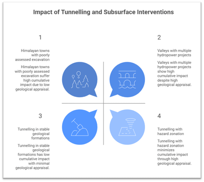
- Example: Instances of ground sinking in Himalayan towns have been linked to poorly assessed underground excavation in fragile geological formations.
Seismic and Structural Sensitivity
- The Himalayas lie in high seismic risk zones, where tunnelling can exacerbate stress redistribution along faults.
- Blasting and mechanical excavation weaken already stressed rock strata, increasing susceptibility to collapse during earthquakes or heavy precipitation.
- Government Initiative: Hazard zonation and micro-seismic studies are mandated under national disaster frameworks, yet their integration into project execution remains uneven.
Cumulative Impact of Multiple Projects
- The concentration of tunnels, dams, and roads within narrow valleys produces a cumulative destabilising effect, often underestimated during fragmented project approvals.
- The absence of basin-level or regional impact assessments leads to piecemeal clearances that ignore long-term geomorphic consequences.
- Case Study: Valleys hosting multiple hydropower and transport projects have shown increased frequency of slope failures compared to relatively undisturbed catchments.
3. Muck Dumping, Altered Drainage, and River System Degradation
Obstruction of Natural Drainage Channels
- Excavated debris from slope cutting and tunnelling is frequently dumped along valley sides or into riverbeds, constricting natural flow paths.
- During intense rainfall, these obstructions cause sudden channel avulsions, converting streams into destructive debris-laden floods.
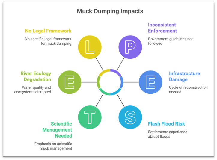
- Example: Settlements downstream of unregulated dumping zones have experienced abrupt flash floods following cloudburst events.
Amplification of Flood Magnitude and Velocity
- Loose muck material is easily mobilised, increasing the sediment load and erosive power of floodwaters.
- This sediment-rich flow damages bridges, roads, and hydropower infrastructure, creating a cycle of reconstruction and renewed exposure.
- Government Initiative: Disaster mitigation guidelines emphasise scientific muck management, yet enforcement remains inconsistent across mountainous regions.
Degradation of River Ecology and Water Security
- Muck dumping degrades water quality by increasing turbidity and disrupting microbial and aquatic ecosystems, particularly in snowmelt-fed upper reaches.
- Loss of riparian vegetation and altered temperature regimes reduce dissolved oxygen levels, affecting river health and downstream livelihoods.
- Case Study: Sensitive Himalayan river stretches designated for ecological protection have shown declining resilience where construction debris enters active channels.
Conclusion:
- The Himalayan disaster trajectory illustrates that unsafe land-use practices are not merely development externalities but central drivers of risk creation.
- As climate change acts as a powerful risk multiplier, the margin for engineering error in the Himalayas is rapidly shrinking.
- Prioritising hazard-sensitive land-use planning, cumulative impact assessments, and ecosystem-based resilience is essential to safeguarding both mountain communities and downstream populations.
Recap: