Great Nicobar Island Development Project: Maritime Security vs Ecological Obligations
Introduction
The Great Nicobar Island Development Project (GNIP) refers to the large-scale infrastructure plan for India’s southernmost Andaman & Nicobar archipelago. The project envisages a transshipment port, airport, township, power plant and logistics hub, representing an investment of approximately ₹80,000 crore.
From a maritime-security perspective the island is strategically located near the Strait of Malacca and the eastern Indian Ocean — offering India potential access to sea-lanes of strategic importance. From an ecological/constitutional angle the island falls under legally protected categories (tribal reserve, biosphere zone, rainforest cover, and prone to seismic/tidal risks) requiring India’s commitment to environmental protection, tribal rights, and international obligations under the Constitution and environmental laws.
However, the project highlights a tension between the strategic ambitions and constitutional-ecological obligations: security and growth versus environmental protection, tribal rights and ecological fragility.
Body
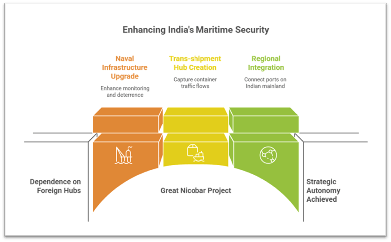
1. India’s maritime-security and growth objectives
A. Strategic location & maritime security
- The island lies just ~90 km from the southern tip of the Malacca Strait, one of the world’s busiest maritime chokepoints.
- The project proposes a naval-capable deep-water port, upgraded airfield and surveillance infrastructure — enhancing India’s ability to monitor sea-lanes in the eastern Indian Ocean, deter hostile presence and strengthen maritime domain awareness.
- In the larger Indo-Pacific context and under the Act East policy, India seeks to project its influence, secure sea-lines, and reduce dependence on foreign transshipment hubs (e.g., Colombo, Singapore). This project is pitched as a “game changer” in that context.
B. Commercial and trade objectives
- As a trans-shipment hub the project aims to capture container traffic that currently flows via foreign ports, thereby saving foreign exchange, generating cargo flows, and positioning India as a regional logistics player.
- It is part of the port-led growth model: better connectivity, improved logistics infrastructure, integrated industrial townships all aimed at boosting economic development in a remote island region.
- Government schemes such as the Sagarmala Programme, National Logistics Policy, and island-development initiatives provide a policy framework for such infrastructure-led growth.
C. Regional integration and geo-economics
- The project envisions integration of the island into a “maritime arc” connecting ports on Indian mainland (e.g., Vizhinjam in Kerala, Vadhavan in Maharashtra) with Great Nicobar as the southern anchor — enhancing India’s footprint in the Bay of Bengal and eastern Indian Ocean.
- From a geoeconomic lens, this aligns with India’s desire to be less reliant on external hubs and more self-sufficient in maritime logistics, thereby increasing strategic autonomy.
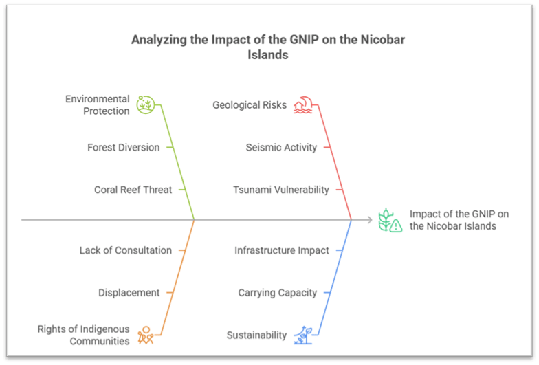
2. Constitutional-ecological obligations and constraints
A. Environmental protection and biodiversity
- The island is covered by tropical rainforest (~85 %+), mangroves, coral reefs, seagrass beds and is home to endemic species (e.g., the Nicobar Megapode bird, leatherback sea turtle nesting in Galathea Bay) ¬– signifying ecological sensitivity.
- India is party to international commitments (e.g., Convention on Biological Diversity) and domestically bound by the Environment Protection Act, Forest Conservation Act, Biodiversity Act and coastal regulation zones (CRZ). The GNIP involves diversion of ~130 sq km of forest land, potential clearance of thousands/millions of trees, threat to coral reefs and mangroves.
- The coastal regulation zone mapping changed: earlier parts of the project area were in CRZ 1A (“no‐go”), but later found to be CRZ 1B (where ports may be allowed) according to the NCSCM.
B. Rights of indigenous tribal communities
- The island is home to indigenous communities including the Nicobarese and the Shompen tribe (particularly vulnerable tribal group, PVTG). Constitutional provisions (Articles 244, 244A, Fifth Schedule) and laws like the Forest Rights Act, 2006, Protection of Aboriginal Tribes Regulation, 1956 mandate proper consultation, consent and safeguarding of tribal habitat, culture and livelihoods.
- The project raises issues of displacement, exposure of the Shompen to disease, loss of livelihood, and lack of proper consultation.
C. Geological, disaster and sustainability risk
- The island lies in a high seismic and tsunami-prone zone (experienced 2004 Indian Ocean tsunami subsidence ~15 feet). Large-scale infrastructure in such zones raises sustainability and risk issues.
- Sustainable development of islands requires carrying-capacity assessments (as per NITI Aayog documents) to ensure that growth does not overwhelm fragile ecosystems.
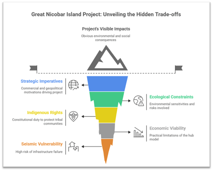
3. Tensions and trade-offs between objectives and obligations
A. Strategic/Commercial imperatives vs Ecosystem fragility
- While the strategic/commercial logic argues for India to build capacity and presence, the ecological constraints highlight that the infrastructure is being proposed in a zone of extremely high environmental sensitivity and risk.
- Example: The project proposes diverting ~130 sq km of forest and cutting perhaps over 1 million trees; the leatherback turtle nesting site in Galathea Bay faces disruption.
- Despite strategic logic, the assumption that “building capacity” will automatically yield transshipment traffic is contested by logistics experts who point out that carrier networks, connectivity, cost‐structures matter. This mismatch exemplifies the tension between aspiration and practical viability.
B. Indigenous/trustee obligations vs Development push
- The constitutional duty to protect tribal rights is in serious tension with the project’s scale and consultative process.
- Example: The Tribal Council of Great & Little Nicobar reportedly revoked its “no objection certificate” for diversion of forest land citing inadequate information.
- The reliance on remote compensatory afforestation (planting in Haryana/Madhya Pradesh) to offset loss of pristine Nicobar forest raises questions of ecological justice and adequacy of mitigation.
C. Risk-management and sustainability vs Aspirational hub model
- The hub model envisaged (massive transshipment port) faces structural limitations: remote location (~1200 km from mainland), lack of hinterland industrial base, higher operating costs for feeder services. This raises the risk that the strategic/commercial ambition may not deliver — yet the ecological and social costs are locked in.
- Example: Logistics experts note that hubs flourish not simply on infrastructure but network connectivity and cargo base — which Great Nicobar lacks.
- The island’s high seismic vulnerability further adds to the risk of large-scale infrastructure failing or imposing heavy adaptation/maintenance cost, undermining sustainability.
Conclusion
The Great Nicobar Island Development Project starkly illustrates the intersection — and friction — between India’s maritime-security and commercial ambitions and its constitutional-ecological obligations. On one hand, strategic logic and economic growth imperatives offer strong motivation; on the other, ecological fragility, tribal rights and disaster-risk demand cautious, inclusive and sustainable planning.
By balancing strategic needs with ecological imperatives and tribal rights — backed by credible data and inclusive governance — India can aspire to responsibly harness the potential of Great Nicobar while honouring its constitutional commitments and safeguarding its unique ecology.